Where Does Tornado Alley Start and End?
Tornado Alley is a concept, not a boundary line. The geography of severe tornado risk in the United States is more complicated than a stripe on a map, and it is shifting.
Tornado Alley is one of those geographic concepts that almost everyone has heard of and almost nobody can accurately define. Ask ten people where it starts and ends and you will get ten different answers. That is not because some of them are wrong. It is because Tornado Alley is not a formally defined geographic region. It is a colloquial term for a zone of elevated tornado frequency across the central United States, and the boundaries drawn around it have always been approximate, contested, and increasingly out of date.
The Conventional Definition
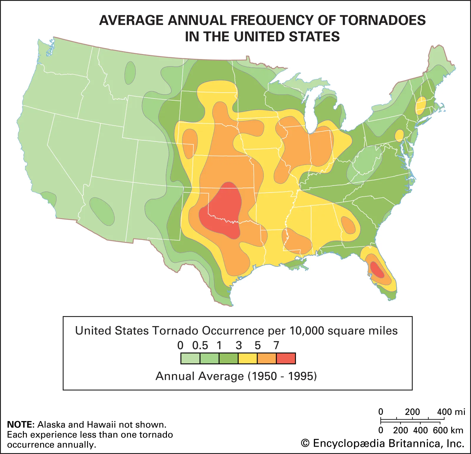
The traditional Tornado Alley runs roughly from northern Texas and Oklahoma northward through Kansas, Nebraska, and into South Dakota. Some maps extend it eastward into Iowa and Missouri, others push it west into the Texas Panhandle and eastern Colorado. The region sits in the area where warm, moist air from the Gulf of Mexico meets cold, dry air flowing south from Canada, and where the jet stream provides the wind shear needed to create rotating thunderstorms.
This convergence zone is geographically real. The southern Plains do produce more tornadoes per unit area than almost anywhere else on earth. The question is whether drawing a fixed boundary around the highest-frequency zone is scientifically useful or just cartographically convenient.
The Starting Points
Tornado Alley, in the conventional telling, begins somewhere around the Red River Valley, the border region between Texas and Oklahoma. This area - Wichita Falls, Lawton, the land between the Caprock Escarpment and the Cross Timbers - sits directly beneath the exit region of the upper-level jet stream during spring and receives ample Gulf moisture during the same period. Dew points in the 60s and 70s pushing north from the Gulf, paired with strong wind shear aloft, create an environment well-suited to supercell development.
Further south, the Texas Panhandle and West Texas are also high-frequency tornado zones, though the terrain there tends to produce somewhat more isolated supercells than the dense outbreak environments of northern Oklahoma and Kansas.
The End Points
Tornado Alley does not end cleanly. In every direction, it tapers into terrain or atmospheric conditions that become progressively less favourable for violent tornadoes.
To the north, the Rocky Mountain Front Range disrupts the moisture flow and changes the atmospheric dynamics. Tornadoes do occur in Wyoming and Montana but they tend to be weaker and less frequent. The cold air source becomes dominant faster than the Gulf moisture can establish itself.
To the east, the transition is more gradual. Arkansas, Missouri, Tennessee, and Mississippi all produce significant tornadoes. The term Dixie Alley has been applied to this corridor, and the distinction between Tornado Alley and Dixie Alley matters: storms in the southeast tend to occur at night, in winter months, and within environments that make visual identification difficult, which historically has contributed to higher death tolls per tornado in that region.
To the west, the increasing elevation and drier boundary layer of the high plains reduces the available moisture and instability. Eastern Colorado and New Mexico do produce tornadoes, but the frequency drops off as you move away from the Gulf moisture axis.
Why the Concept is Shifting
The climatological picture of tornado risk in the United States is not static. Multiple studies over the past decade have identified a shift in tornado frequency away from the traditional Great Plains corridor and toward the southeast. The reasons are not fully resolved, but changes in Gulf moisture patterns, evolving jet stream behaviour, and possibly land use changes across the Plains are all potential contributors.
This shift matters practically. Communities in Arkansas, Tennessee, Mississippi, and Alabama are now experiencing tornado environments that are statistically more dangerous than the traditional Tornado Alley regions, partly because of the frequency shift and partly because the terrain, forest cover, and nighttime occurrence of southeast tornadoes make them harder to observe and escape.
The 1974 Super Outbreak - still one of the most studied tornado events in history - sent violent tornadoes deep into Ohio, Indiana, and Alabama, well beyond any conventional Tornado Alley boundary. The 2011 Super Outbreak similarly devastated Alabama and Mississippi. Neither outbreak was a geographic anomaly. They were reminders that the conceptual boundary of Tornado Alley has always understated the true risk area.
What the Boundary Gets Wrong
The biggest problem with Tornado Alley as a concept is that it implies relative safety beyond its edges. This is demonstrably false. Significant and violent tornadoes have occurred in nearly every US state. The 1953 Flint tornado killed 116 people in Michigan. New England has produced historic tornadoes. The Deep South experiences tornadoes throughout the winter months in environments that have nothing to do with the classic Plains supercell pattern.
The frequency map that underlies the Tornado Alley concept is real and meaningful for planning and research purposes. What it should not do is create a mental boundary that causes people outside it to underestimate their own risk.
The States Most Clearly Within the Core
If you are looking for the states where the classic Tornado Alley environment - Gulf moisture, strong low-level shear, elevated mixed layer capping that breaks explosively in the afternoon - is most consistently realised, they are:
Oklahoma sits at what most meteorologists consider the epicentre. No state has a higher concentration of research activity, operational storm chasing, and severe weather infrastructure. The 1999 Oklahoma outbreak and El Reno 2013 both centred here.
Kansas produces reliable tornado environments from April through June, with the highest frequency concentrated in the central and south-central part of the state. The 1991 Andover tornado and the 2012 Woodward tornado are examples of the kind of violent, long-track events the state regularly produces.
Texas produces more tornadoes by raw count than any other state, though the size of the state partially explains this. The most extreme events tend to concentrate in the northern half - the Panhandle, North Texas, and the Red River corridor.
Nebraska and South Dakota mark the northern end of the classic pattern. Supercell environments still develop regularly, though the peak season shifts later into June and the character of the storms can differ from the more explosive overnight capping environments further south.
Where to Begin
Tornado Alley starts where the Gulf moisture meets the jet stream over a landscape flat enough to let supercells develop unimpeded. It ends where the terrain rises, the moisture thins, or the atmospheric dynamics become less favourable. Exactly where those transitions occur changes year to year and even day to day.
If you want to understand the actual geography of tornado risk in the United States, the NOAA Storm Prediction Center's historical density maps are more useful than any fixed boundary line. Tornado Alley is a starting point for understanding. It is not a property boundary.
Archives for storm chasers and meteorology obsessives
Museum-quality prints and technical apparel built on real data. Designed by those who chase.


