2011 Tuscaloosa–Birmingham Tornado: April 27 EF4 Super Outbreak
The Tuscaloosa–Birmingham EF4 tornado of April 27, 2011 was one of the deadliest storms of the historic Super Outbreak. 64 killed along a 79-mile path. Full archive, path map, and radar data.
Overview
April 27, 2011 was the most active tornado day since the 1974 Super Outbreak. 216 tornadoes were confirmed in a single 24-hour period across the southeastern United States. Among them, a single EF4 supercell tracked 80.7 miles from Greene County through the heart of Tuscaloosa and into north Birmingham, killing 64 people and injuring 1,500. The tornado was visible from miles away and broadcast live on television. None of that proximity to media, population, or infrastructure slowed its destructive path through two of Alabama's most populated urban areas.
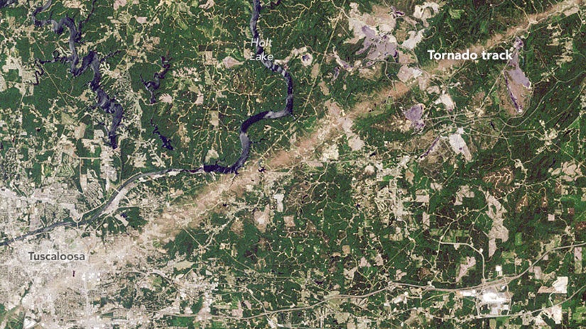
NASA satellite image showing the continuous 80-mile tan scar across the Alabama landscape after April 27
The Setup
The environment on April 27 was among the most conductive for violent tornado production ever documented over the Deep South. A powerful shortwave trough drove massive low-level jet enhancement across the Gulf States overnight, depositing deep moisture into a region already primed by days of warm advection. By afternoon, surface dew points in Alabama were in the upper 60s Fahrenheit, and the wind shear profile showed veering with height that was extreme by any regional standard. The Tuscaloosa-Birmingham storm organized on a pre-existing boundary near the Mississippi-Alabama state line and never weakened.
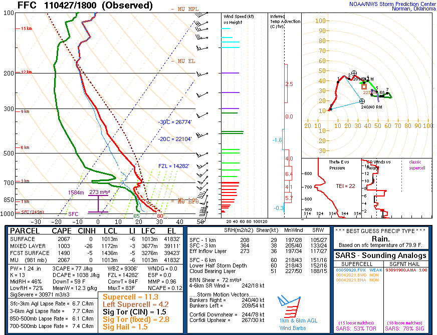
April 27 2011 atmospheric sounding profile showing extreme CAPE and shear over central Alabama
The Tornado
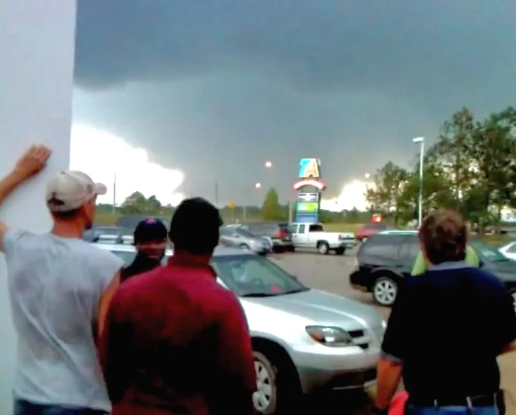
Because the tornado was visible for miles in the relatively open terrain west of Tuscaloosa, it received continuous live television coverage during its approach. Security camera footage from the city itself documented the complete transformation of the western sky into a featureless dark mass as the wedge closed within a mile. It crossed McFarland Boulevard at peak intensity, destroying a commercial strip and beginning its path through residential neighborhoods along Alberta City. Two elementary schools in the path were critically damaged. The storm entered north Birmingham before weakening near the Jefferson County line, never fully roping out at any point along the 80-mile track.
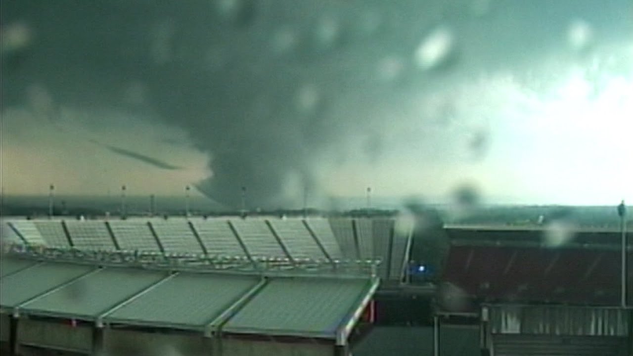
Photograph of the Tuscaloosa tornado at maximum intensity as it crossed McFarland Boulevard, viewed from the University of Alabama campus
The Terrain Question
One of the longstanding assumptions in tornado meteorology was that complex terrain, rolling hills, and valleys would break up or weaken long-track supercells. The Tuscaloosa-Birmingham track offered a direct test of this assumption. North Alabama is not flat. The storm crossed multiple ridges and valleys in the Appalachian foothills northeast of Tuscaloosa without any measurable weakening in the wind field. Satellite imagery from NASA confirmed a continuous damage scar through terrain that previous modeling suggested should have disrupted the mesocyclone. The terrain assumption has been largely abandoned in the literature following this event.
What Changed
The Tuscaloosa-Birmingham event permanently altered two fields. In engineering, the long-track data confirmed that unreinforced slab-on-grade construction in the Southeast was systemically vulnerable to EF4 and above loads, including structures that met current code. In ecology, the satellite documentation of the outbreak's forest damage showed swaths of debarked and uprooted trees altering local canopy cover measurably for over a decade. The ecological record of a tornado outbreak preserved in tree damage, soil disturbance, and satellite imagery is now a recognized secondary data source for historical reconstruction of storms that predate radar.