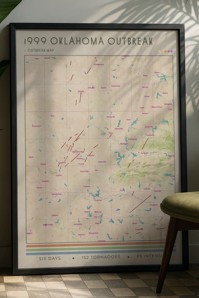
1999 Oklahoma Tornado Outbreak
The 1999 Oklahoma tornado outbreak was a large, historic, and devastating event that took place across much of the central United States from May 2nd to May 8th, with the most dramatic activity unfolding during the afternoon of May 3rd through the early morning of May 4th. During the week-long sequence, 152 tornadoes touched down. Oklahoma experienced its largest tornado outbreak on record, with 70 confirmed. The most significant was the F5 Bridge Creek-Moore tornado, which tracked from near Bridge Creek through southern Moore and into the eastern Oklahoma City metropolitan area. A University of Oklahoma Doppler on Wheels mobile radar unit measured a wind speed of 321 mph within the vortex, the highest wind speed ever recorded on Earth by a ground-based instrument. The Bridge Creek-Moore tornado killed 36 people and injured 583. Overall, 50 people lost their lives during the outbreak and damage amounted to $1.4 billion, making the Bridge Creek-Moore tornado the first billion-dollar tornado in history.
The Meteorological Setup
The atmosphere across the southern Great Plains on May 3rd was primed for violent tornadoes. A deepening surface low was positioned over the western Texas panhandle, drawing rich Gulf moisture northward into Oklahoma. Surface dewpoints were in the upper 60s to low 70s°F. A strong upper-level jet streak was providing exceptional wind shear, with hodographs showing large, curved profiles that strongly favoured supercell development and tornado production.
The Storm Prediction Center had issued a high risk for parts of central Oklahoma and southern Kansas. The convective outlook explicitly mentioned the potential for strong to violent tornadoes. This was a well-forecast event, and the Oklahoma severe weather community was alert.
The Bridge Creek-Moore Tornado
The tornado formed near Amber, Oklahoma shortly before 7:00 PM CDT and tracked northeast through Bridge Creek, Newcastle, and into Moore. It reached F5 intensity as it passed through the Moore area, producing catastrophic damage across residential subdivisions.
The damage path through Moore was roughly a mile wide at its peak. Homes in the direct path were swept from their foundations completely. Vehicles were thrown and wrapped around structures. The concrete slabs of destroyed homes were scoured. The damage indicators across the widest and most intense portion of the path were consistent with the upper end of the Fujita Scale.
The DOW radar measurement of 321 mph occurred within a sub-vortex of the tornado. This measurement was taken at roughly 30 metres above ground level. While the surface-level winds were almost certainly lower than the measured value aloft, the reading remains the highest ever recorded and confirmed the extreme intensity of the vortex, similar to the multi-vortex tornado types observed in the Jarrell tornado. Meteorologists estimate that over 600 lives were saved due to the timely and accurate warnings provided by the modernised WSR-88D radar network, tracking clear hook echo signatures.
Gary England and Live Coverage
The May 3rd event was one of the first major tornado events to be covered continuously on live television with real-time Doppler radar data. Gary England, chief meteorologist at KWTV in Oklahoma City, provided live coverage that is widely credited with saving lives. His broadcasts tracked the tornado in real time, calling out specific intersections and neighbourhoods in the tornado's path and urging immediate shelter.
The combination of excellent NWS warnings and continuous live television coverage meant that the population in the tornado's path had more advance warning than almost any previous tornado event of this scale. The death toll of 36 from the Bridge Creek-Moore tornado, while significant, was remarkably low given the F5 intensity and the population density of the affected area. The May 3rd event is frequently cited as evidence that effective communication saves lives during tornado events. A tragic secondary effect was noted: several people died while attempting to take shelter under interstate overpasses, a practice that the NWS later campaigned against due to the wind tunnel effect that increases wind speed and debris risk at those locations.
What Changed
The 1999 Oklahoma outbreak prompted several significant changes in how tornado threats are communicated and how communities respond.
The concept of "tornado emergency" language was developed in the aftermath. The NWS Norman office had used unusually direct language during the event, moving beyond standard warning text to convey the extreme severity of the threat. This approach was later formalised and has been used in subsequent major tornado events.
The event also accelerated discussions about community storm shelters and residential safe rooms. Moore, Oklahoma would go on to be struck by additional violent tornadoes in 2003 and 2013, and each event reinforced the case for below-ground shelter access in tornado-prone residential areas.
The DOW wind measurement contributed to ongoing discussions about the relationship between measured wind speeds and the damage-based ratings of the Fujita Scale. The 321 mph reading demonstrated that the most extreme tornadoes can produce winds well beyond what is required for the highest damage rating, a discussion that continued prominently after the El Reno tornado.
We mapped the 1999 Oklahoma Outbreak as a cartographic print. It is in the shop.