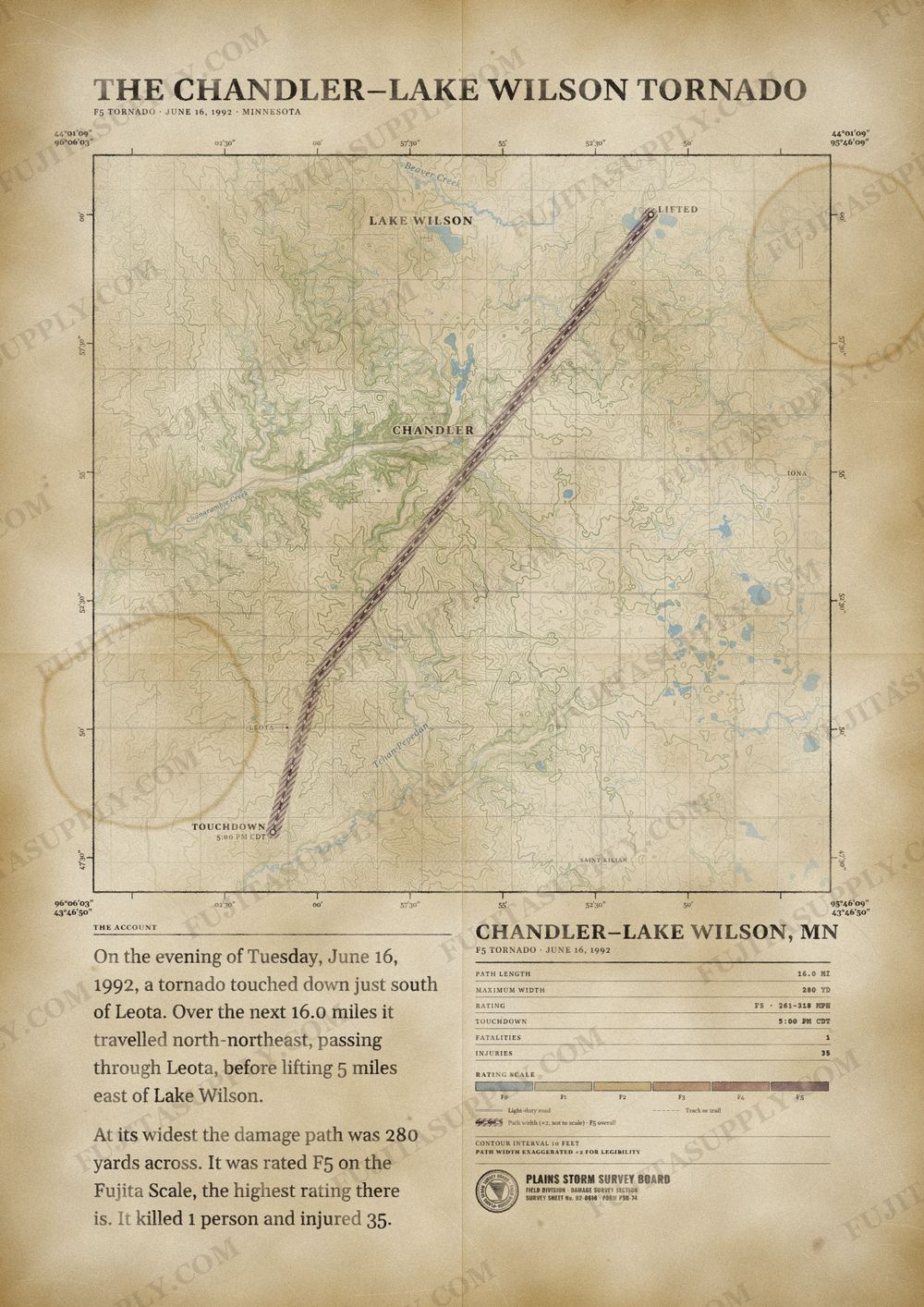
Chandler-Lake Wilson Tornado Map
During the afternoon hours of June 16, 1992, a large and violent tornado, commonly known as the Chandler–Lake Wilson tornado, tore through the small towns of Chandler and Lake Wilson in Murray County, Minnesota. The damage in Chandler was extreme enough for the local National Weather Service office to rate the damage F5 on the Fujita scale, which included the destruction of the Chandler-Lake Wilson High School building on the west side of town. This tornado is the most recent F5/EF5 tornado in the state of Minnesota, and is the second most recent U.S. tornado to occur in June, the most recent being the 2025 Enderlin Tornado.
The path of the Chandler-Lake Wilson tornado
On the evening of Tuesday, June 16, 1992, a tornado touched down just south of Leota. Over the next 16.0 miles it traveled north-northeast, passing through Leota, before lifting 5 miles east of Lake Wilson.
At its widest the damage path was 280 yards across. It was rated F5 on the Fujita Scale, the highest rating there is. It killed 1 person and injured 35.
The track, widths and figures on this map come from the Storm Prediction Center's survey record, so they can differ slightly from totals published elsewhere.
What was the Chandler-Lake Wilson tornado?
The Chandler-Lake Wilson tornado was a large and violent storm that struck Murray County, Minnesota, on June 16, 1992. It tore through the towns of Chandler and Lake Wilson during the afternoon hours. The National Weather Service officially assigned the event an F5 rating on the Fujita scale due to extreme damage. This event remains the most recent F5 or EF5 tornado to occur in the state of Minnesota.
What was the Chandler-Lake Wilson tornado wind speed?
The provided text does not specify a numerical value for the wind speeds of the Chandler-Lake Wilson tornado. The National Weather Service rated the intensity of the damage as F5 on the Fujita scale. This classification indicates the level of structural destruction observed rather than a direct measurement of wind velocity. The tornado caused catastrophic damage, including the total leveling of parts of Chandler.
What was the Chandler-Lake Wilson tornado path?
The tornado touched down 2 miles south of Leota before moving northeast. It traveled a total distance of 35 miles according to the local National Weather Service office. Discrepancies exist in official records, with the Storm Prediction Center listing the path at 16 miles. The tornado reached a maximum width of .75 miles as it moved through the Murray County region.
How many people died in the Chandler-Lake Wilson tornado?
One person died from injuries sustained during the Chandler-Lake Wilson tornado. The victim succumbed to those injuries two months after the event. In addition to the fatality, the tornado injured over 40 people. Specifically, 36 individuals suffered injuries within the town of Chandler alone.
What did the Chandler-Lake Wilson tornado destroy?
The tornado leveled half of the town of Chandler and destroyed multiple farmsteads east of Leota. It obliterated the Chandler-Lake Wilson High School building on the west side of town. The storm also demolished the local water tower and various businesses throughout the area. Rural parts of Murray County sustained significant damage to infrastructure and property throughout the 35 mile track.
What caused the Chandler-Lake Wilson tornado?
A 500-millibar area of low pressure over the Rocky Mountains influenced the trajectory of the storm system. By late afternoon, a potent jet stream overspread the region, creating highly sheared environmental conditions. A classic triple point setup emerged as a dry line formed ahead of an approaching cold front. This configuration combined with rising dew points and an elevated mixed layer to trigger an explosion in convection.
What happened after the Chandler-Lake Wilson tornado?
Communities including Leota, Chandler, and Lake Wilson initiated cleanup and reconstruction efforts immediately following the destruction. Residents rebuilt homes on the same plots of land and replaced the damaged Chandler water tower. The NWS Sioux Falls office documented the recovery process in 2022 to compare the landscape ten years later. Despite lingering psychological effects for residents, the region successfully achieved a full recovery.
