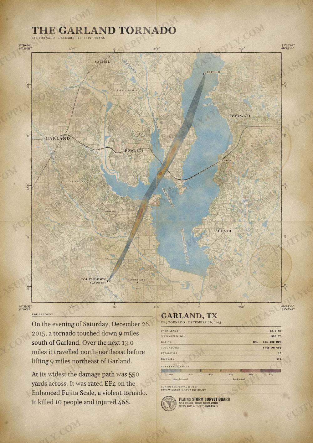
Garland Tornado Map
On the night of December 26, 2015, a violent EF4 tornado struck the Dallas suburbs of Sunnyvale, Garland, and Rowlett, located in Texas. It caused $20–26 million (2015 USD) in damages, killed 10 people, making it the deadliest tornado in the United States in 2015, and injured 468 others. This was the third tornado to be rated an EF4 in the United States that year and the fourth such tornado worldwide.
The path of the Garland tornado
On the evening of Saturday, December 26, 2015, a tornado touched down 9 miles south of Garland. Over the next 13.0 miles it traveled north-northeast before lifting 9 miles northeast of Garland.
At its widest the damage path was 550 yards across. It was rated EF4 on the Enhanced Fujita Scale, a violent tornado. It killed 10 people and injured 468.
The track, widths and figures on this map come from the Storm Prediction Center's survey record, so they can differ slightly from totals published elsewhere.
What was the Garland tornado?
The Garland tornado struck the Dallas suburbs of Sunnyvale, Garland, and Rowlett, Texas, on the night of December 26, 2015. This violent EF4 tornado killed 10 people and injured 468 others during its track. It ranks as the deadliest tornado to hit Texas in the month of December. The storm caused between $20 million and $26 million in damages to the local area.
What was the Garland tornado wind speed?
The Garland tornado reached peak wind speeds of 180 mph. These winds classified the event as an EF4 on the Enhanced Fujita scale. While the intensity fluctuated throughout the track, the violent nature of the rotation caused significant structural failure. Later analysis by experts sometimes debated these ratings, but the official National Weather Service assessment established the EF4 intensity based on observed damage indicators.
What was the Garland tornado path?
The tornado first touched down at 6:46 p.m. CST on East Tripp Road, located north of US 80 near Sunnyvale in Dallas County. It tracked northeastward through Garland and Rowlett before moving into Rockwall County. The vortex finally dissipated over Lake Ray Hubbard at 7:02 p.m. CST. The entire journey across North Texas spanned 13.04 miles in length with a peak width of 550 yards.
How many people died in the Garland tornado?
The Garland tornado killed 10 people and injured 468 others during its lifespan. Nine of the fatalities occurred at the I-30 and President George Bush Turnpike interchange when the vortex tossed vehicles off the elevated ramps. The victims in that area ranged from one to 77 years of age. A tenth person died in Rowlett after his home collapsed on him.
What did the Garland tornado destroy?
The tornado destroyed or severely damaged more than 600 homes and businesses throughout its track. It flattened apartment complexes, leveled residential homes on Crestpoint Lane, and obliterated multiple RVs at the Plantation Place Dallas RV Park. The storm also ripped apart infrastructure, including highway signs, power poles, and light poles. At the I-30 interchange, the tornado swept vehicles off bridge ramps and into traffic below.
What caused the Garland tornado?
A potent upper-level trough and a large low-pressure area from Mexico created the conditions for the supercell. High dew points between 60 and 70 degrees provided ample moisture from the Gulf of Mexico. Low-level shear measured at 50 kts combined with MUCAPE values reaching 2878 J/kg to fuel the storm. These atmospheric conditions generated discrete supercells that produced several tornadoes throughout North Texas that day.
What happened after the Garland tornado?
First responders arrived to manage rescue efforts while facing rain, wind, and cold temperatures. President Barack Obama declared a major disaster, which authorized federal funding for repairs and housing for displaced residents. The city enacted a 24-hour curfew to keep roads clear for emergency vehicles. Authorities later improved safety measures by installing new sirens and a new operations center to handle future severe weather.

Frequently Asked Questions
Did the Garland tornado kill anyone?
What time did the Garland tornado hit?
What was the EF rating of the Garland tornado?
How much damage did the Garland tornado cause?
Was the Dominator at the Garland tornado?
Citations
Related Tornadoes
Holly Springs-Ashland Tornado
Tate, Marshall, Benton, and Tippah counties, Mississippi
Rochelle-Fairdale Tornado
Lee County, Ogle County, DeKalb County, Boone County, Illinois
St. Louis-East St. Louis Tornado
Missouri, Illinois
Tri-State Tornado
Missouri, Illinois, Indiana