Perryville Tornado Map
Just after nightfall on February 28, 2017, a violent tornado struck just outside of the city of Perryville, Missouri, causing devastating damage to multiple homes and neighborhoods before crossing the Mississippi River into Illinois, where many rural communities and farmsteads were impacted. The tornado was part of a prolific and widespread winter outbreak that impacted much of both the Mississippi and Ohio River Valleys. One person was killed and a dozen others were injured in its wake, with damage estimates totaling nearly $15 million. The tornado tracked a long path of 53.47 miles (86.05 km), and at a maximum width of 1,100 yards (0.63 mi; 1.0 km) from Perry County, Missouri, to Franklin County, Illinois, during its over hour-long lifetime before dissipating southwest of Christopher, Illinois.
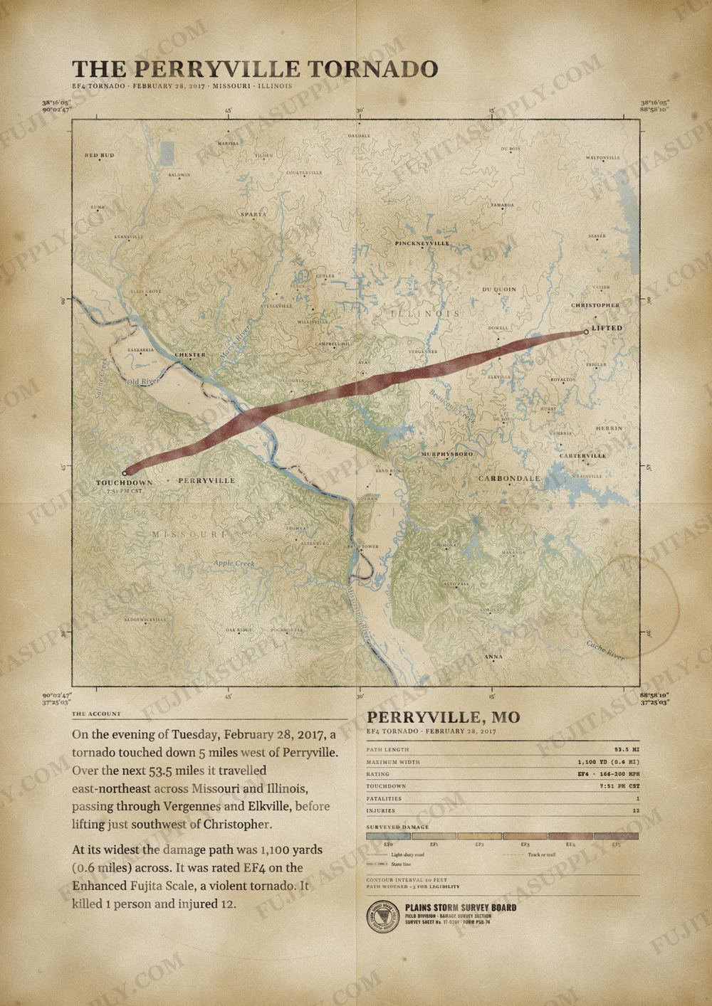
The path of the Perryville tornado
On the evening of Tuesday, February 28, 2017, a tornado touched down 5 miles west of Perryville. Over the next 53.5 miles it traveled east-northeast across Missouri and Illinois, passing through Vergennes and Elkville, before lifting just southwest of Christopher.
At its widest the damage path was 1,100 yards (0.6 miles) across. It was rated EF4 on the Enhanced Fujita Scale, a violent tornado. It killed 1 person and injured 12.
The track, widths and figures on this map come from the Storm Prediction Center's survey record, so they can differ slightly from totals published elsewhere.
What was the Perryville tornado?
The Perryville tornado was a violent EF4 vortex that struck southeastern Missouri and southern Illinois on the evening of February 28, 2017. The storm touched down four miles west of Perryville and caused extensive damage across multiple communities. It crossed the Mississippi River and tracked through mostly rural farmlands and woods. The tornado dissipated just southwest of Christopher, Illinois, after completing a path of 53.5 miles.
What was the Perryville tornado wind speed?
Meteorologists estimated the peak wind speed of the Perryville tornado at 180 mph. This maximum velocity occurred in Perry County, Missouri, near Interstate 55 and U.S. Highway 61. The storm maintained extreme intensity as it moved into Illinois, where winds reached 160 mph south of Mulkeytown and 145 mph near Vergennes. These wind speeds placed the vortex in the EF4 category on the Enhanced Fujita scale.
What was the Perryville tornado path?
The Perryville tornado path began four miles west of Perryville, Missouri, at 7:51 p.m. CST. The vortex traveled 53.5 miles in a northeast direction across the Mississippi River into Illinois. The track crossed Perry County in Missouri before moving through Randolph County, Jackson County, and Franklin County in Illinois. The storm finally dissipated southwest of Christopher, Illinois, at 8:57 p.m. CST.
How many people died in the Perryville tornado?
One person died in the Perryville tornado during its 53.5-mile track. The lone fatality occurred when the vortex intercepted a southbound vehicle on Interstate 55 in Perry County, Missouri. The storm tossed the pickup truck 100 yards into a field and ejected the 24-year-old male driver. The event also caused 12 injuries, all of which occurred in Perry County where the storm reached its maximum intensity.
What did the Perryville tornado destroy?
The Perryville tornado destroyed or damaged at least 100 homes in Perry County, Missouri. The storm leveled five houses northwest of Perryville and blew unoccupied cars from a salvage yard onto Interstate 55. In Illinois, the vortex snapped thousands of trees and destroyed dozens of structures across Jackson County. The winds also swept a block-foundation house completely away south of Mulkeytown and snapped seven power poles along Illinois Route 3.
What caused the Perryville tornado?
An isolated supercell thunderstorm ahead of a cold front caused the Perryville tornado. The atmospheric environment featured a destabilizing air mass with surface dew points in the lower to mid 60s. A mid-level impulse from Oklahoma interacted with a substantially increasing southwesterly low-level jet during the evening hours. These specific meteorological conditions provided a highly favorable environment for the development of strong, long-track tornadoes across the region.
What happened after the Perryville tornado?
The aftermath of the Perryville tornado involved extensive recovery efforts across the affected communities. Local emergency management officials established a downtown storefront to distribute donated food, clothing, and building materials. Utility crews worked to restore electricity to 2,200 customers who lost power during the storm. Missouri Governor Eric Greitens visited the damaged areas and offered state assets to assist hundreds of volunteers clearing debris from properties and farm fields.