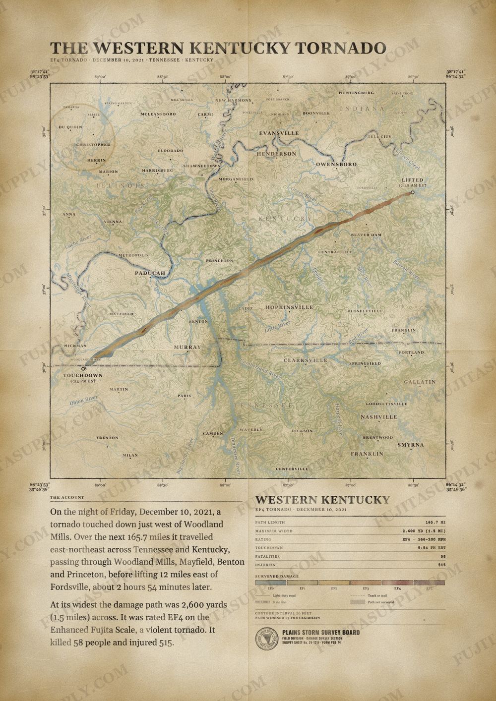
Western Kentucky Tornado Map
During the late evening hours of December 10, 2021, a massive and devastating high-end EF4 tornado, sometimes referred to as the Western Kentucky tornado, Mayfield tornado, or The Beast, tracked a significant distance across Western Kentucky, United States, producing severe-to-catastrophic damage in numerous towns, including Mayfield, Princeton, Dawson Springs, and Bremen. This tornado was the second significant tornado in an exceedingly long-tracked tornado family; it began just inside northern Obion County, Tennessee – a few miles after another long-tracked tornado that traveled through northeast Arkansas, the Missouri Bootheel, and northwest Tennessee – and dissipated in western Obion County. After crossing into Kentucky, the tornado moved through eleven counties of the Jackson Purchase and Western Coal Field regions, at times becoming wrapped in rain during its almost three-hour lifespan that covered 165.6 miles (266.5 km). It was the deadliest and longest-tracked tornado in the outbreak that produced numerous, strong tornadoes in several states; this tornado caused 57 deaths. It became the first violent tornado to strike the state of Kentucky since a deadly 2012 EF4 tornado that occurred over 9 years prior. The tornado is estimated to have caused at least $507 million in damages.
The path of the Western Kentucky tornado
On the night of Friday, December 10, 2021, a tornado touched down just west of Woodland Mills. Over the next 165.7 miles it traveled east-northeast across Tennessee and Kentucky, passing through Woodland Mills, Mayfield, Benton and Princeton, before lifting 12 miles east of Fordsville, about 2 hours 54 minutes later.
At its widest the damage path was 2,600 yards (1.5 miles) across. It was rated EF4 on the Enhanced Fujita Scale, a violent tornado. It killed 58 people and injured 515.
The track, widths and figures on this map come from National Weather Service damage surveys, so they can differ slightly from totals published elsewhere.
What was the Western Kentucky tornado?
The Western Kentucky tornado was a violent EF4 vortex that devastated portions of Tennessee and Kentucky on the night of December 10, 2021. The storm originated in Obion County, Tennessee, before crossing the state line and traveling through eleven Kentucky counties. It reached its maximum intensity in communities such as Mayfield, Dawson Springs, and Bremen. The National Weather Service recorded the total path length at approximately 165 miles, making it an exceptionally long-lived winter weather event.
What was the Western Kentucky tornado wind speed?
Meteorologists estimated the peak wind speed of the Western Kentucky tornado at 190 mph. This maximum velocity occurred in Muhlenberg County, where the storm completely swept poorly anchored houses off their foundations near Bremen. The tornado also produced winds of 188 mph in Graves County and 180 mph in both Caldwell and Hopkins counties. These extreme wind speeds justified the official EF4 rating on the Enhanced Fujita scale across multiple segments of the damage track.
What was the Western Kentucky tornado path?
The Western Kentucky tornado path began near Woodland Mills, Tennessee, at 8:54 p.m. CST. The vortex moved northeast across the state line into Fulton County, Kentucky, and proceeded through Hickman, Graves, Marshall, Lyon, Caldwell, Hopkins, Muhlenberg, and Ohio counties. It fluctuated in width, reaching a maximum of 2,600 yards in Hickman County. The tornado finally dissipated at Rough River Dam State Park in Grayson County at 11:48 p.m. CST after crossing into Breckinridge County twice.
How many people died in the Western Kentucky tornado?
The Western Kentucky tornado killed 58 people and injured 515 others along its track. Graves County suffered the highest casualties, recording 24 fatalities and 210 injuries after the storm struck the city of Mayfield. Hopkins County reported 15 deaths and 200 injuries, while 11 people died in Muhlenberg County. Caldwell, Marshall, Fulton, and Lyon counties accounted for the remaining eight fatalities, with no deaths occurring in the Tennessee segment or the final Kentucky counties.
What did the Western Kentucky tornado destroy?
The Western Kentucky tornado destroyed thousands of structures, including homes, businesses, and agricultural facilities. In Mayfield, the storm demolished a candle factory, crippled emergency headquarters, and leveled historic brick buildings in the downtown district. The vortex wiped out a large residential neighborhood in Dawson Springs and heavily damaged the University of Kentucky Research and Education Center in Princeton. The intense winds also snapped hundreds of thousands of trees and derailed a train in Hopkins County.
What caused the Western Kentucky tornado?
A powerful low pressure system and an unseasonably warm environment caused the Western Kentucky tornado. Strong southern winds brought abundant moisture into the region, pushing temperatures to record highs for December. A deepening surface low and a strong upper-level trough provided extreme vertical wind shear across the lower Ohio Valley. These unstable atmospheric conditions allowed a discrete supercell thunderstorm to develop in Arkansas and travel uninhibited for hundreds of miles across multiple states.
What happened after the Western Kentucky tornado?
Government agencies and charitable organizations launched massive relief efforts after the Western Kentucky tornado. The state activated the National Guard to assist local authorities with search and rescue operations in devastated communities like Mayfield. Relief funds provided financial assistance for displaced residents to secure temporary housing, food, and clothing. Organizations such as Samaritan's Purse purchased land to build 60 new homes for renters who lost their residences during the catastrophic weather event.