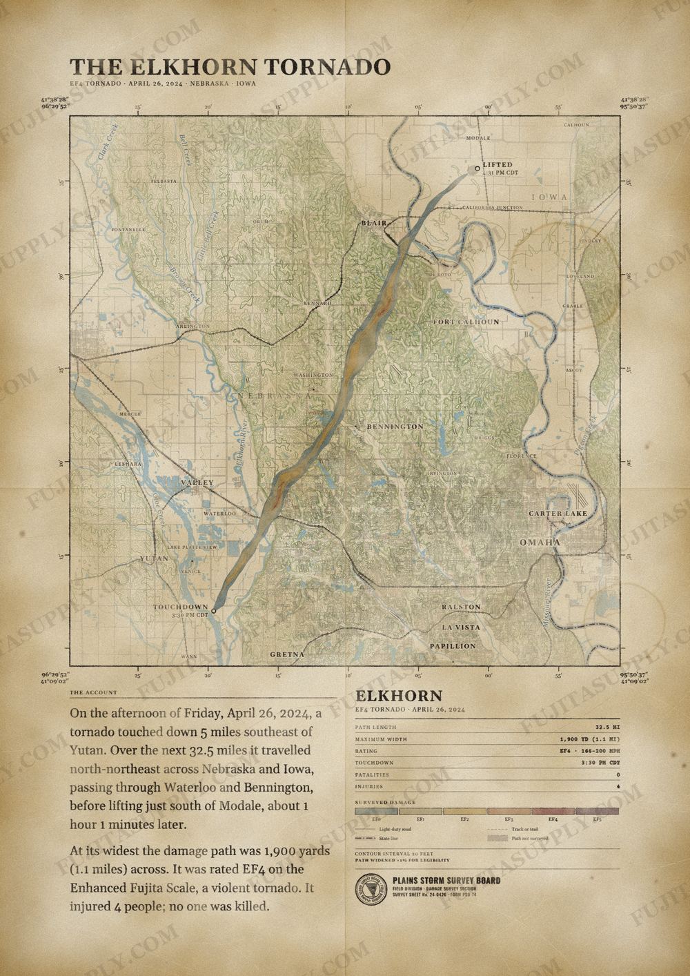
Elkhorn Tornado Map
On the afternoon of April 26, 2024, a large and violent tornado moved through the Omaha metropolitan area, striking the communities of Waterloo, Elkhorn, Bennington, and Blair in Nebraska, resulting in four injuries. The tornado was part of a destructive tornado outbreak that occurred across the Midwestern, Southern, and High Plains regions of the United States between April 25 and 28, and was the first of two violent tornadoes that occurred during the outbreak. The tornado reached peak intensity in the Omaha neighborhood of Elkhorn and south of the city of Blair, leading the National Weather Service in Omaha, Nebraska to assign a rating of low-end EF4 on the Enhanced Fujita scale, with maximum wind speeds estimated at 170 mph (270 km/h).
The path of the Elkhorn tornado
On the afternoon of Friday, April 26, 2024, a tornado touched down 5 miles southeast of Yutan. Over the next 32.5 miles it traveled north-northeast across Nebraska and Iowa, passing through Waterloo and Bennington, before lifting just south of Modale, about 1 hour 1 minutes later.
At its widest the damage path was 1,900 yards (1.1 miles) across. It was rated EF4 on the Enhanced Fujita Scale, a violent tornado. It injured 4 people; no one was killed.
The track, widths and figures on this map come from National Weather Service damage surveys, so they can differ slightly from totals published elsewhere.
What was the Elkhorn tornado?
The Elkhorn tornado was a violent EF4 vortex that struck eastern Nebraska and western Iowa on the afternoon of April 26, 2024. The storm developed during a severe weather outbreak that produced 24 confirmed tornadoes across the Omaha warning area. It caused extensive damage in the communities of Elkhorn, Bennington, and Blair. The tornado crossed the Missouri River into Iowa before dissipating near Modale.
What was the Elkhorn tornado wind speed?
Meteorologists estimated the peak wind speed of the Elkhorn tornado at 170 mph. This velocity placed the storm in the EF4 category on the Enhanced Fujita scale. These maximum winds occurred in Douglas County and Washington County, where the tornado completely destroyed multiple homes. Surveyors used this severe structural damage to determine the official wind speed estimation.
What was the Elkhorn tornado path?
The Elkhorn tornado touched down in western Douglas County, Nebraska, at 2:30 p.m. CST. It traveled a total distance of 31.89 miles in a northeast direction. The path crossed Douglas County and Washington County in Nebraska before moving into Harrison County, Iowa. The storm finally lifted approximately two miles southwest of Modale, Iowa, at 3:31 p.m. CST.
How many people died in the Elkhorn tornado?
Zero people died in the Elkhorn tornado during its 31.89-mile track across Nebraska and Iowa. The event resulted in a total of four reported injuries. Douglas County recorded three of these injuries as the storm moved through populated subdivisions like Ramblewood. Washington County accounted for the single remaining injury, while Harrison County reported no casualties.
What did the Elkhorn tornado destroy?
The Elkhorn tornado completely destroyed multiple homes in the Ramblewood subdivision and along rural county roads. It collapsed new development houses near Fort Street and removed roofs in the Newport Landing neighborhood. The storm derailed empty rail container cars at a Cargill plant in Washington County. In agricultural areas, the vortex flipped numerous center pivots, demolished horse barns, and snapped power poles.
What caused the Elkhorn tornado?
The Elkhorn tornado originated from a long-track supercell that initiated in Jefferson and Saline counties. Atmospheric conditions included a potent negatively-tilted shortwave trough moving into the central Plains. A jet streak on the downstream side of this trough provided substantial divergence aloft over Nebraska. At the surface, a warm front moved north through the area just after noon, creating an environment favorable for severe thunderstorms.
What happened after the Elkhorn tornado?
The provided sources do not contain information about the recovery or relief efforts after the Elkhorn tornado. The National Centers for Environmental Information records detail the meteorological setup, the path, and the structural damage. Surveyors evaluated the destruction to assign the EF4 rating and estimate the peak wind speeds. No details regarding emergency response, sheltering, or cleanup operations appear in these official summaries.