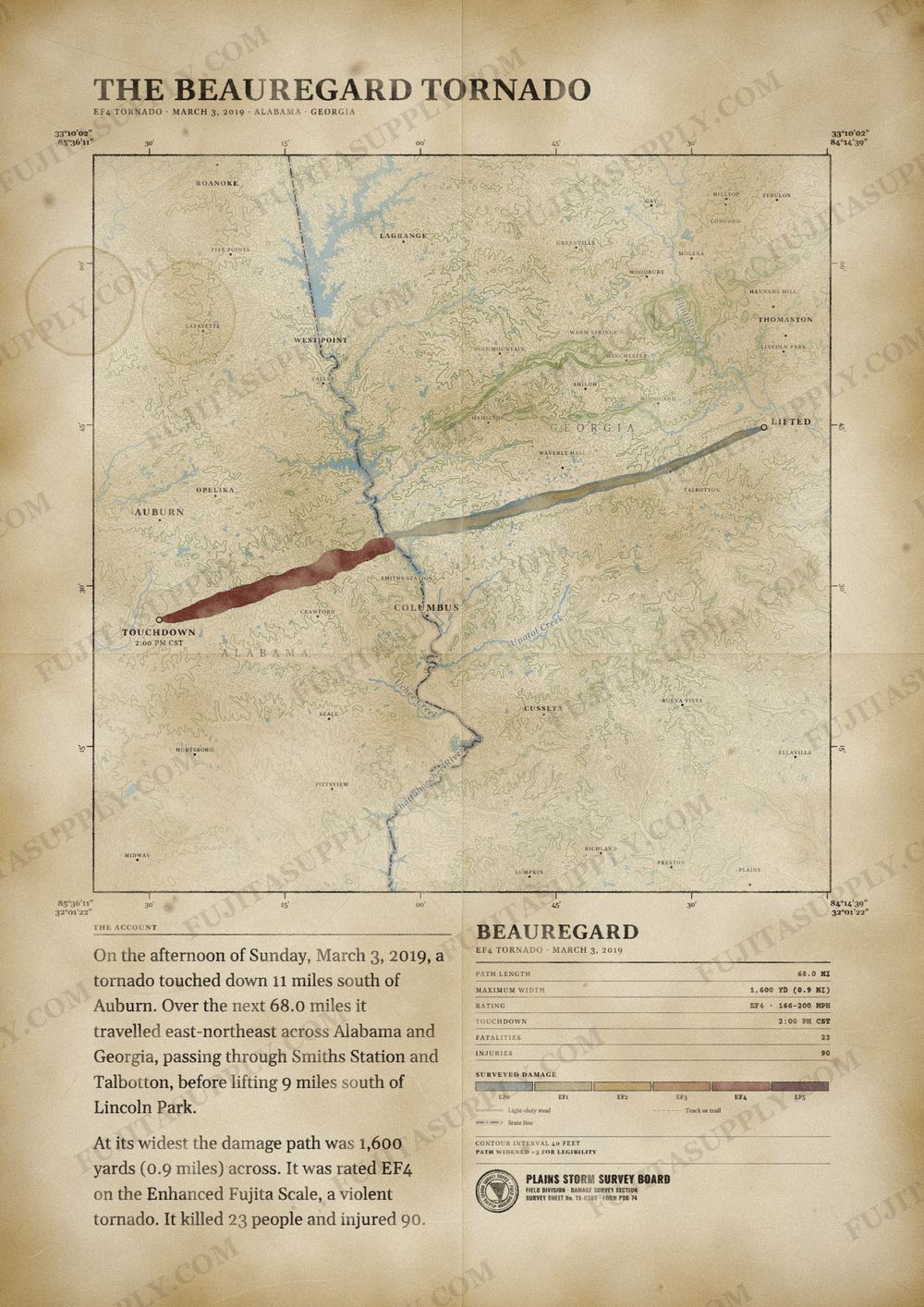
Beauregard Tornado Map
On the afternoon of March 3, 2019, a violent and long-tracked EF4 tornado struck portions of eastern Alabama and western Georgia, causing extreme damage along its path. This tornado was the deadliest tornado in the United States since the 2013 Moore tornado, killing 23 and injuring 97, in addition to being the first EF4 tornado to occur in the United States since a tornado near Canton, Texas, on April 29, 2017. This tornado was part of a larger tornado outbreak that affected the Southeastern United States on this same day. This outbreak produced numerous tornadoes across Alabama and Georgia. This was the deadliest and strongest tornado of this outbreak, and the 8th deadliest in Alabama state history.
The path of the Beauregard tornado
On the afternoon of Sunday, March 3, 2019, a tornado touched down 11 miles south of Auburn. Over the next 68.0 miles it traveled east-northeast across Alabama and Georgia, passing through Smiths Station and Talbotton, before lifting 9 miles south of Lincoln Park.
At its widest the damage path was 1,600 yards (0.9 miles) across. It was rated EF4 on the Enhanced Fujita Scale, a violent tornado. It killed 23 people and injured 90.
The track, widths and figures on this map come from the Storm Prediction Center's survey record, so they can differ slightly from totals published elsewhere.
What was the Beauregard tornado?
The Beauregard tornado was a deadly EF4 vortex that struck Alabama and Georgia on March 3, 2019. The storm emerged during a widespread severe weather event that produced numerous tornadoes across the southeastern United States. It caused extensive damage in Lee County, Alabama, before crossing the Chattahoochee River into Georgia. The tornado inflicted significant structural damage on communities including Smiths Station, Ellerslie, and Talbotton along its path.
What was the Beauregard tornado wind speed?
National Weather Service meteorologists estimated the peak wind speed of the Beauregard tornado at 170 mph. This maximum velocity occurred in southern Lee County, Alabama, placing the storm in the EF4 category. The tornado produced 140 mph winds as it reached EF3 intensity in Muscogee County, Georgia. Earlier in its life cycle, the storm generated maximum sustained winds of 88 mph in Macon County, Alabama.
What was the Beauregard tornado path?
The Beauregard tornado path spanned 68 miles across two states. The vortex touched down in Macon County, Alabama, at 2:00 p.m. CST and moved northeast into Lee County. It crossed the Chattahoochee River into Muscogee County, Georgia, at 3:29 p.m. EST. The tornado then tracked through Harris County before dissipating in Talbot County at 4:16 p.m. EST.
How many people died in the Beauregard tornado?
The Beauregard tornado killed 23 people during its progression across Alabama and Georgia. All 23 fatalities occurred in Lee County, Alabama. The storm also caused a total of 90 injuries along its 68-mile track. Seven of these injuries happened in Talbot County, Georgia, while the remainder occurred in Alabama. No casualties were reported in Macon, Muscogee, or Harris counties.
What did the Beauregard tornado destroy?
The Beauregard tornado destroyed hundreds of homes, vehicles, and structures along its track. In Lee County, the American Red Cross estimated the storm destroyed 225 homes and inflicted major damage on 133 others. The vortex leveled a well-anchored house, collapsed a church roof, and toppled a cellular communications tower. In Talbot County, the winds completely demolished the cinder block Humble Zion Church and blew two apartment buildings down to their foundation slabs.
What caused the Beauregard tornado?
An upper-level disturbance and a surface low pressure system caused the Beauregard tornado. A warm front moved northward from the Florida Panhandle, bringing warm, moist, unstable air into central Alabama. This boundary stalled near the Interstate 85 corridor as the surface low strengthened and moved eastward. Supercell thunderstorms developed in this unstable environment during the afternoon, generating the tornado.
What happened after the Beauregard tornado?
The sources provide limited information about what happened after the Beauregard tornado. The American Red Cross evaluated the destruction in Lee County and estimated that 225 homes were destroyed. National Weather Service meteorologists surveyed the damage path across Alabama and Georgia to determine the intensity of the storm. They documented the structural and timber damage to establish the official wind speed estimates and track details.