Linwood Tornado Map
During the early evening hours of May 28, 2019, a large and heavily rainwrapped tornado struck the western Kansas City metropolitan area, across Douglas and Leavenworth Counties in eastern Kansas. It was the second violent (F4/EF4+) tornado to occur during a five-day long tornado outbreak across the United States, which spawned approximately 182 tornadoes with the first EF4 tornado occurring a day prior in the Dayton area in Ohio. In its wake, the tornado caused $48 million USD in total damages within the two counties, with nearby areas in the vicinity or within southeastern Lawrence, and Linwood taking the worst damage during the event. According to the National Weather Service weather forecasting offices (WFOs) in both Topeka, Kansas and Kansas City in Missouri, the tornado was ultimately rated as low-end EF4 on the Enhanced Fujita scale, with estimated winds of 170 mph (270 km/h), though a storm chasing research team found winds of 190 mph (310 km/h) from a rocket probe. It caused 4 injuries but no fatalities before dissipating west of Bonner Springs, Kansas.
The path of the Linwood tornado
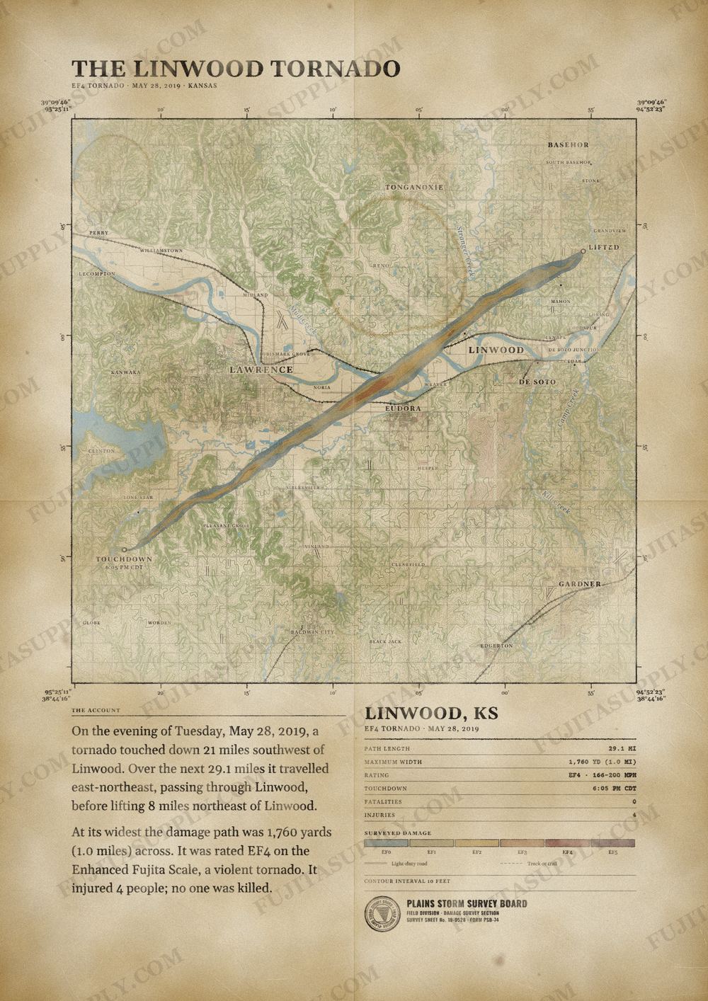
On the evening of Tuesday, May 28, 2019, a tornado touched down 21 miles southwest of Linwood. Over the next 29.1 miles it traveled east-northeast, passing through Linwood, before lifting 8 miles northeast of Linwood.
At its widest the damage path was 1,760 yards (1.0 miles) across. It was rated EF4 on the Enhanced Fujita Scale, a violent tornado. It injured 4 people; no one was killed.
The track, widths and figures on this map come from the Storm Prediction Center's survey record, so they can differ slightly from totals published elsewhere.
What was the Linwood tornado?
The Linwood tornado was an EF4 vortex that struck eastern Kansas on the evening of May 28, 2019. The storm originated south of Lawrence and moved northeast across the Kansas River. It heavily impacted rural residences and the city of Linwood before dissipating near Bonner Springs. This event was the strongest tornado to strike the Kansas City metropolitan area since 2003.
What was the Linwood tornado wind speed?
Meteorologists estimated the peak wind speed of the Linwood tornado at 170 mph. This velocity placed the storm in the EF4 category on the Enhanced Fujita scale. The most intense winds occurred as the vortex crossed the Kansas River and entered Leavenworth County. A meteorological probe launched into the tornado core recorded a three-dimensional wind speed of 85.1 meters per second at an altitude of 475 meters.
What was the Linwood tornado path?
The Linwood tornado path began east of Lone Star Lake in Douglas County at 5:05 p.m. CST. The vortex traveled a total distance of 29.1 miles in a northeast direction. The track crossed Highway 10 and the Kansas River before moving into Leavenworth County. The storm passed through the Linwood and Basehor areas before lifting southwest of the Kansas Speedway at 6:00 p.m. CST.
How many people died in the Linwood tornado?
Zero people died in the Linwood tornado during its 29.1-mile track. The National Centers for Environmental Information recorded four official injuries in Douglas County. News reports and episode summaries indicated up to 18 total injuries across the region, primarily involving storm chasers in vehicles. The storm bypassed the most densely populated sections of Lawrence and Linwood, which limited the number of casualties.
What did the Linwood tornado destroy?
The Linwood tornado destroyed 44 homes and 159 accessory structures in Leavenworth County. The storm demolished 11 buildings at Free State Growers and inflicted heavy damage on a country market in Douglas County. It collapsed brick walls at a daycare center in Lawrence and uprooted numerous trees along its path. The property damage in Leavenworth County alone reached an estimated $26 million.
What caused the Linwood tornado?
A high-precipitation supercell thunderstorm caused the Linwood tornado. This parent storm developed during the afternoon of May 28 across Lyon County, Kansas, and tracked northeast through the evening. The system produced several tornadoes across eastern Kansas and northwestern Missouri. The storm absorbed a smaller circulation south of Lawrence, which allowed the main vortex to intensify and widen as it approached the Kansas River.
What happened after the Linwood tornado?
Following the Linwood tornado, emergency management officials coordinated relief efforts through a regional telephone system. Residents dropped off 16 truckloads of bottled water, cleaning supplies, and tarpaulins at Basehor-Linwood High School. Structural engineers from the University of Kansas conducted a door-to-door damage assessment of 271 homes to study building code vulnerabilities. Westar Energy deployed 120 linemen to replace 200 downed poles and restore power to 3,700 customers.