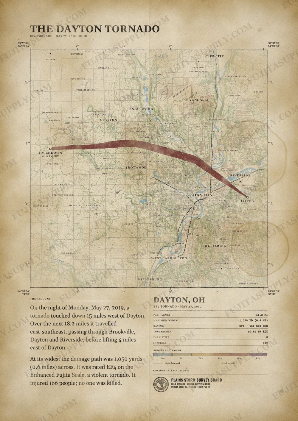
Dayton Tornado Map
On the night of May 27, 2019 (Memorial Day), a large and destructive tornado struck Dayton, Ohio as well as the surrounding suburbs of Brookville, Trotwood, Northridge and Riverside, injuring 166 people and indirectly killing one person. Part of a larger severe weather outbreak, the tornado was the first of two EF4-rated tornadoes to touch down during the outbreak, with the other occurring in Kansas a day later. It was the first EF4 tornado in Ohio since the tornado that struck Millbury in 2010. Along the tornado's 18.17-mile (29.24 km) path through Montgomery County, the tornado was on the ground for 32 minutes, reaching a peak width of 1,050 yards (960 m) at times, and causing an estimated total of $500 million (2019 USD) in damage.
The path of the Dayton tornado
On the night of Monday, May 27, 2019, a tornado touched down 15 miles west of Dayton. Over the next 18.2 miles it traveled east-southeast, passing through Brookville, Dayton and Riverside, before lifting 4 miles east of Dayton.
At its widest the damage path was 1,050 yards (0.6 miles) across. It was rated EF4 on the Enhanced Fujita Scale, a violent tornado. It injured 166 people; no one was killed.
The track, widths and figures on this map come from the Storm Prediction Center's survey record, so they can differ slightly from totals published elsewhere.
What was the Dayton tornado?
The Dayton tornado was a violent EF4 vortex that struck Montgomery County, Ohio, on the evening of May 27, 2019. This Memorial Day storm caused heavy damage across several communities, including Brookville, Trotwood, and Dayton. It was part of a larger outbreak of thunderstorms that produced multiple strong to violent tornadoes across the region. The tornado inflicted severe structural damage on residential subdivisions and commercial districts before dissipating in Riverside.
What was the Dayton tornado wind speed?
Meteorologists estimated the peak wind speed of the Dayton tornado at 170 mph. This velocity placed the storm in the lower end of the EF4 category on the Enhanced Fujita scale. These maximum winds occurred as the tornado crossed the Stillwater River near Riverside Drive in Montgomery County. The intense winds completely removed roofs and exterior walls from well-built apartment buildings and debarked numerous trees in this corridor.
What was the Dayton tornado path?
The Dayton tornado followed an 18.2-mile path entirely within Montgomery County, Ohio. The storm touched down just west of Brookville at 9:41 p.m. EST and carved a track toward the east and southeast. It moved through Trotwood, Northridge, and the Old North Dayton area while crossing Interstate 75. The tornado eventually weakened and lifted in a subdivision north of Burkhardt Road in Riverside at 10:13 p.m. EST.
How many people died in the Dayton tornado?
The Dayton tornado caused one indirect fatality during its progression across Montgomery County. An 86-year-old woman died on September 1, 2019, from injuries she sustained after becoming trapped in her home during the storm. The official National Weather Service records list zero direct fatalities for the event. However, the violent winds and collapsing structures resulted in 166 reported injuries among residents in the affected communities.
What did the Dayton tornado destroy?
The Dayton tornado destroyed nearly 3,000 homes and impacted more than 200 businesses along its track. The storm caused $500 million in property damage, leveling garages and collapsing exterior walls in Brookville and Trotwood. Well-built apartment buildings in Dayton suffered complete roof removal and structural failure. The intense winds also destroyed hardwood trees along the Stillwater River, debarking trunks and snapping branches.
What caused the Dayton tornado?
The Dayton tornado originated from severe thunderstorms that developed during the evening hours of May 27. These storms formed along a warm front that was lifting slowly north across the Ohio region. This weather system produced a large episode of severe weather that generated multiple strong to violent tornadoes. The specific storm cell that spawned this vortex intensified as it moved into Montgomery County, eventually reaching EF4 status.
What happened after the Dayton tornado?
Following the Dayton tornado, affected neighborhoods remained without power for up to six weeks. Residents relied on generators to stay in their damaged homes while waiting for insurance adjusters to assess the destruction. The Montgomery County Emergency Management agency announced on June 18 that survivors could apply for short-term recovery assistance from FEMA. Rebuilding the first properties took over a year as residents navigated government paperwork and contractor delays.